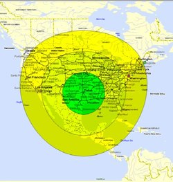
 EPA ASPECT 3hr, 6hr & 9hr Response Coverage with 1 aircraft
 The EPA ASPECT program is highlighted in the June, 2012 edition of Geospatial Today. In the article “Aiding National Response”, Paul Lewis describes the successful EPA ASPECT program.
According to the article, core requirements of the EPA ASPECT program included:
The EPA ASPECT program as established meets these core goals.
A fundamental need in an emergency is to have equipment and teams available who can react quickly. They must arrive on the scene of the emergency rapidly, and provide an assessment to the on-scene commander. This enables decision making. Every emergency situation is different, and often quickly evolving. The EPA ASPECT program gives the on-scene commander an information edge.
Building a National EPA ASPECT ProgramThe EPA ASPECT aircraft and program team are on call and operational today. They are prepared to be wheels up within one hour of first call. Expansion of this successful program to establish a national network of similar on-call, properly equipped aircraft will allow complete national coverage. With this national coverage, the EPA ASPECT program will scale gracefully to be ready to respond. With the correct number of aircraft and appropriate sensor systems the program can provide emergency response to any incident in under three hours.
In the article, the author relates specific examples in which data from the EPA ASPECT program has improved emergency response.
He concludes:
The ASPECT Program model compiled by Dr Thomas for controlling cost and maintaining a 24 hour a day 7 days a week operational capability is directly applicable and scalable to a national program.
Proven technology, in service and operational today, makes a persuasive case for expanding our national resources. The EPA ASPECT program is a successful model for expanding to a national scale.
Geospatial TodayGeospatial Today is a focused magazine that maps the diverse applicability of and innovations in the geospatial sector.
According to the article, core requirements of the EPA ASPECT program included:
- Cost-effective operation, maintenance and use of the aircraft
- Affordable COTS sensor technology
- Rapid dispatch/wheels up in under one hour after activation
- Airborne data collection under cloud ceilings
- Timely automated onboard data processing facilitating real or near-real-time chemical and radiological data analysis with low false alarm rates
- High-resolution day/night ortho-rectified imagery
- Data telemetry to and from the aircraft
- All data, analysis products, and information must be geospatially registered
- Seamless and direct integration of data and information to incident
commanders: local, state, and federal joint operations centers
The EPA ASPECT program as established meets these core goals.
A fundamental need in an emergency is to have equipment and teams available who can react quickly. They must arrive on the scene of the emergency rapidly, and provide an assessment to the on-scene commander. This enables decision making. Every emergency situation is different, and often quickly evolving. The EPA ASPECT program gives the on-scene commander an information edge.
Building a National EPA ASPECT ProgramThe EPA ASPECT aircraft and program team are on call and operational today. They are prepared to be wheels up within one hour of first call. Expansion of this successful program to establish a national network of similar on-call, properly equipped aircraft will allow complete national coverage. With this national coverage, the EPA ASPECT program will scale gracefully to be ready to respond. With the correct number of aircraft and appropriate sensor systems the program can provide emergency response to any incident in under three hours.
In the article, the author relates specific examples in which data from the EPA ASPECT program has improved emergency response.
He concludes:
The ASPECT Program model compiled by Dr Thomas for controlling cost and maintaining a 24 hour a day 7 days a week operational capability is directly applicable and scalable to a national program.
Proven technology, in service and operational today, makes a persuasive case for expanding our national resources. The EPA ASPECT program is a successful model for expanding to a national scale.
Geospatial TodayGeospatial Today is a focused magazine that maps the diverse applicability of and innovations in the geospatial sector.
 RSS Feed