The nation’s only 24/7 airborne stand-off chemical and radiological detection and imagery platform
    • Home
    • About
    • Services
      • Equipment
    • News
    • Case Studies
    • Contact

    our services

    Airborne ASPECT supports emergency responses, homeland security missions, environmental surveys, and climate monitoring missions by providing local, state, and federal operation centers with radiological and chemical detection and photographic imagery.

    Picture
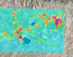
    An exposure rate contour map

    Radiation or Radiological Event Detection

    ASPECT's Gamma Emergency Mapping (GEM) technology improves the nation’s airborne gamma-screening and mapping capability of ground-based gamma contamination following a wide-area radiological dispersal device (RDD), improvised nuclear detonation (IND), or nuclear power plant (NPP) accidents.
    • Utilizes commercially available state-of-the-art hardware and software
    • Provides the only airborne remote sensing system in the country with a versatile NaI and LaBr crystal detection setup
    • Applies IAEA, DOE, and EPA processing algorithms 
    • Offers near real-time product development based on customer input
    Picture
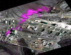
    Infrared image of methane plume release

    Chemical Detection

    ASPECT can detect and quantify gaseous constituents present in the air column between the aircraft and the ground using the principles of remote passive infrared detection via a Fourier transform infrared spectrometer (FTS) to detect and quantify gaseous constituents present in the air column between the aircraft and the ground.

    ASPECT’s chemical detection software filters out common atmospheric constituents as it automatically searches for 78 chemical compounds, near real-time, in the air column below the aircraft.
    Picture
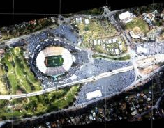
    Rapid response map of the 2009 Rose Bowl. 

    Aerial imagery

    ASPECT provides first responders with critical situation data in the form of high-resolution aerial images, enhanced with chemical and radiological information and displayed using easy-to-use technology like Google Earth.
    • Available infrared and photographic images with geospatial chemical and radiological information 
    • All imagery is geo-rectified using both aircraft attitude correction (pitch, yaw, and roll) and GPS positional information
    • Georeferenced high resolution oblique images
    • Image processing is composed of two primary steps including image enhancement and geo-registration
    • If requested, aerial photography (and IR imagery) can be stitched into a wide area mosaic
    • All displayed and easily access via Google Earth or a secure FTP site; Google and GIS compatible formats

    Our customers

    • Sporting Events – Olympics, Super Bowl, Marathons, etc.
    • Government Ceremonies and Inaugurations
    • Homeland Security 
    • Aerial and Ground Radiological Surveys
    • Real-time situational awareness information for first responders
    See Case studies

    Deployment

    Airborne ASPECT is a 24/7/365 response-ready service that can be wheels up within an hour of activation. We'll be on station, collecting data, anywhere in the continental United States within nine hours.
    • Once on-scene collect chemical, radiological, or situational data (imagery) using established collection procedures
    • Process all data within the aircraft using tested automated algorithms
    • Extract the near real time data from the aircraft using a broadband satellite system and rapidly QA/QC the data by a dedicated scientific reach back team
    • Provide the qualified data to the first responder enabling them to make informed decisions in minimal time

    Picture

    Copyright 2015, Airborne ASPECT, Inc.
    8209 Marathon Dr., Plano, TX 75024 | airborneaspect@airborneaspect.com
    Picture
    Back to top